Showing posts with label Traffic signals. Show all posts

Monday, March 12

Mail Bag: A whole lot of I-10 stuff, FM 1103 at I-35, US 281 at the Guadalupe River

I'm curious about some of the project dates on this web site. On the Upcoming Projects page, the project to build the bridge over I-10 at Balcones Creek Road and convert the frontage roads to one-way between Fair Oaks Parkway and the Bexar-Kendall county line is scheduled to start in 2018. The project to expand the US 87 and TX 46 bridges over I-10 and convert the frontage roads to one-way between Scenic Loop Road and TX 46 is also scheduled to start in 2018.
However, the project to convert the frontage roads to one-way between Scenic Loop Road and the Bexar-Kendall county line is shown as starting in 2026. Is that a mistake, or will the other projects actually take 8 years to complete before this project is required?
Also, can you share an estimated completion date for the Fair Oaks Parkway bridge over I-10?
- Lee

Those dates are drawn from our project tracker, which pulls from our Unified Transportation Program. The UTP is updated every year and gives a comprehensive look at our 5- and 10-year plans. The middle segment, between Scenic Loop Road and the Bexar-Kendall county line, is placed last on the list of segments to be finished for one-way frontage roads conversion due to budgeting constraints. We'll start before 2026 if we can secure the funds to do so.
Each of those projects, which will often move forward concurrently, will take about three years to finish (that's a generic time range for reference; each project has its own timeframe).
As for the completion of the Fair Oaks Parkway bridge over I-10, RELMCo Inc. is on pace to have that wrapped up this summer. That's summer 2018. As in just a few months from now.


First of all, thanks for the great work you do with the mailbag. It’s always a fun - and informative - read!
I’ve been curious about the use of panels on Wurzbach Parkway over Blanco Road. These are the green wall-like structures that prevent drivers on Wurzbach Pkwy from looking down onto Blanco. To put it simply: what purpose do they serve?
Similar overpasses of the Parkway over West Ave., Jones Maltsberger, Nacogdoches, and Perrin-Beitel don’t have these panels. What’s special about Blanco?
- Juan

First of all, thank you and you're welcome!
Those panels are visual barriers, preventing the headlights of evening drivers from peering into apartment windows immediately adjacent to Wurzbach Parkway right there. It also maintains some semblance of privacy for the residents. You should find similar visual barriers along the eastbound lanes of Wurzbach Parkway over Perrin-Beitel.
While there is an apartment complex at the corner of West Avenue and Wurzbach, it is set far enough back from the highway and is separated from the parkway with a strip of trees. These natural barriers eliminate the need for the visual barrier panels you're seeing at Blanco.


Who is responsible for the timing of the signals on Hausman at 1604? In both directions the signal on the near side of 1604 turns green at the same time as the signal on the far side.
- Jim

Those signals are timed by the city of San Antonio. We'll reach out to our friends there to ask they take a look at the issue.


Thank you for the post about speed limits on I-10. I think I am the only one driving 60 mph and cars ride my bumper and pass me like crazy. Please add more speed limit signs and the LED reader boards. Thank you.
- Beth

We're happy to do what we can to improve the safety along any highway corridor. We'll take a look at this and other corridors and see if there are any additional signs we can add to improve awareness of the speed limits. That said, what typically helps the most in this area is enforcement of the speed limit, which we understand will be increasing as work continues to move forward.


With the bridge replacement project on I-35 at FM 1103, we know that the turn around lanes have been added to the original project. The last we had heard the move of the exits IS NOT included on this project. The northbound 35 exit to 1103 is already too close to 1103 and adding the turnaround lane will compound that issue. Have the plans changed to address the exits or what will it take to prevent the inevitable crashes that will happen frequently on a short exit with turnaround lanes?
- Jeff

The turnarounds were included with the project when it bid and were part of the actual design of the project. They may not have been part of the package presented in public meetings but were certainly part of the plans when we got bids from contractors.
The distance between the end of the ramp and the start of the intersection, heading north, is about 600 feet. We actually have design standards giving us the desired distance at an intersection like this. The total volume of the frontage road and the ramp is less than 2,500 vehicles per hour. The total traffic volume of FM 1103 at this location is just a shave higher than 750 vehicles per hour. We have three or more lanes for traffic to weave between the ramp and the intersection.
As you can see, Table 3-16 shows we like to have at least 460 feet between the end of the ramp and the intersection at a location like this. We have about 600 feet, exceeding by more than 30 percent the design requirements for an approach like this.
Knowing we've exceeded the design criteria as we have, we are confident this location will continue to be a safe intersection enjoyed by all.


Is there any plan to go back between Huebner and DeZavala to add an entrance to I-10 west? The only entrance that is left is very dangerous with all the traffic from the Huebner area merging with the Fredericksburg road traffic to merge to get onto I-10 west then merge with all the traffic getting off at UTSA Blvd.
- Max

The short answer here, Max, is no. The distances involved out there are beyond adequate to handle what we've got, and since we've had the current configuration in place (it's been a few years) we've seen no crash data to suggest any real hazard. It's actually in line with the standard used across the country. Adding another entrance to westbound I-10 would be redundant and actually create hazards.
If you don't remember the way the road was configured prior to the project in 2012 that built I-10 between Huebner and Lp 1604 as you know it today, we actually had two on ramps from Huebner Road. We eliminated one as a way to improve safety, and that safety enhancing configuration is the one you're seeing today.


I am still wondering about the I-10 project from Ralph Fair to fair oaks Ranch. According to the info provided at the open house the schedule for this project was:
  • Begin Construction ― I-10 improvements (frontage road conversion, ramp reversals, and Old Fredericksburg Rd / Buckskin Dr overpass): Fall of 2015
  • Fair Oaks Pkwy Bridge: Fall of 2016
  • Construction time ― I-10 improvements: Approximately 2 Years
  • Construction time ― Fair Oaks Pkwy Bridge: Approximately 1 Year
That indicates that the I-10 improvements was to run from Fall 2015 2 years to Fall 2017. It is now early Spring 2018 and this project is several months from being done. It appears to me the contractor under-resourced this project from the start.
What happened? Weather can not be blamed for all this delay. What is a realistic completion date now?
-Bob

Bob, we're glad you asked. First off, timetables given at those open house meetings are based on best engineering guesses with the plans not fully fleshed out. When you got these dates we didn't have full plan sheets drawn out and the target timeframes were goals to be met.
We began work on the I-10 improvements late March 2016 - a six-month delay from our intended start date due to some utility conflicts in the area - with a timeline of just over two years. We still have a few months from time expiring on the contract. If work isn't complete at that point we'll charge liquidated damages for each day the project continues beyond the contracted completion date. While we don't decide for the contractor the resources they ought to commit to a project, the consequence at the end of the job is, essentially, the contractor working for free (which is bad business for any private business).
By the way, the Fair Oaks Parkway bridge project began early 2017 with an 18-month schedule. We are currently on track to finish before the end of the school year, which is actually a bit ahead of the contract requirement.
One last thing: You'll recall in the open house we discussed totally closing the bridge and having it built in one piece to meet that construction timeline of a year. That plan was scrapped at the behest of those attending the open house who didn't like the idea of eliminating access to the bridge long-term. We were clear at the time the requested construction process would about double the duration of the project.


What is the estimated time to completion for the work at US 281 and the Guadalupe river? Also, what is being done? Thanks.
- John

This is a project that's really run under the radar, despite being a fairly major project up in Comal County. Thanks for bringing it out for us, John.
We are updating the southbound bridge deck over the Guadalupe River. That means a new bridge deck, new bridge rail (replacing the steel barrier with concrete barrier), cleaning up the bridge structure and the like. We've also recently added some pavement repair to the scope of work on the project.
All told work should be finished next summer (that is, Summer 2019). Between now and then you'll see a variety of traffic shifts. As those happen we'll do our best to get them posted here.

Tuesday, February 27

Mail Bag: I-10 frontage roads at Old Fred, signal timing, enforcement and more

Can you please explain the multiple construction delays that have occurred at Old Fredericksburg Rd and I-10 frontage Road. It was closed in October and targeted for December and had been delayed now for the 3rd time to March! How does this now take 6 months to add drainage?! Yes we’ve had rain, ice, and snow days but not for 4 months straight. This detour has been a major pain to get around for those that live in neighborhoods off the frontage roads.
- Christina
Please clarify how 4-6 days of inclement weather would cause a completion date to be extended over 90 days? Original completion was to be Dec 23.

- Vicky
We'll pull no punches here. We went directly to the contractor to find out what is going on and to let them know of the danger they're in of having their reputation in the public harmed.
Back in December Sundt's area director said they were going to work hard to get the road reopened to two-way traffic. At that time the items to get constructed before the frontage road could be reopened included a culvert and headwall, dirt work to develop the two roadway lanes and laying asphalt, curb and sidewalk. That road surface was to be wide enough for barrier so they could continue to work on a retaining wall.
At the time Sundt said they could get all that done in about 5-6 weeks, not including the mandatory break over Christmas. After adding the likelihood of inclement weather their assessment showed a completion of mid- to late-February.
So much for that idea. Here's what they said mid-February in an email update:
"Obviously, we did not make the second or third week in February to open up the westbound frontage road. We left the (storm water detention) pond construction out of the prior list on what needs to be done before the paving can go in. The access is really tight as well for the wall construction."
These are the two biggest reasons they're giving us for the delay. The lesson we're learning on our end is the need for milestones on work like this; we left the milestone off during planning as a judgment call believing the intersection would be built quickly as it was broken into quadrants. That omission won't happen in the future.
As for now, Sundt is working on that retaining wall and the pond, as well as the culvert that was being built. They have brought in two additional concrete crews to get the concrete work moving faster. Pavement work needs to wait a bit for dry weather as well as these other tasks to wrap up.
From Sundt's area manager: "We are making this corner of the intersection a priority on the job, but there is just a lot to take care of."
At the time of the email update we got a rough estimate on when Sundt would have things wrapped up. In that note they estimated:
  • Retaining wall, three more weeks
  • Concrete pads lining the pond, two more weeks
  • Concrete channel for the box culvert, two more weeks
  • Road grading and asphalt work, two weeks (cannot begin until wall and pond are finished)
  • Concrete curb, sidewalks and island, two weeks (cannot start until after the road grading and asphalt work is done)
  • Best-case scenario is to get two-way traffic reopened by March 21
Sundt isn't making the corner a priority just for fun, either. At this point they need to finish in order to do other work. As soon as they have that southeast corner of the future intersection of Old Fredericksburg Road and I-10 reopened they'll flip over to the northwest side. They'll then work around to the northeast and then the southwest quadrants. If that sounds painful, here's some assurance from that same area manager:
"These other three quadrants will go much quicker due to roadway pavement reconstruction being the only aspect of work to be done in these areas."
That is, they only have the actual roadway to mess with in the other quadrants - not a ton of drain structures.
Once the intersection is built Sundt will go to work on the new exit and entrance ramps, which need to be in place before we can switch traffic to one-way.


What do orange flags on top of stop sign mean? Thanks
- Anthony
Those are actually there just to make the sign more visible. Check out section 2A.15 in our Manual for Uniform Traffic Control Devices online.


Who is responsible for signal light timing on Loop 1604 near Randolph AFB between Hanover Cove and Lower Seguin Rd? It seems as though the lights are perfectly timed to make you stop at each intersection, almost without fail.
Synchronizing the lights would really help to alleviate traffic buildups here.
- Marshall
Thanks for bringing this issue up, Marshall. Those signals should be ours to time. Keep in mind they're not on a true timer - those days are over. We use instead a video infrared vehicle detection system (VIVD) on those signals, which act as smart devices to trigger the signals when a prescribed volume of traffic hits the intersection from a given direction.
We'll have our traffic operations folks check out those signals to make sure they're operating the way they should.


Just wondering whether anyone enforces the "no trucks in left lane" signs on I-35 north of 1604 through New Braunfels? I drive that section daily and see a truck using the lane at least once a week, sometimes even blocking traffic or cutting off cars. Do you have more information on the purpose of those signs? Thanks for all of your posts!
- John
On any major highway the left lane is primarily for passing. Where semi truck traffic is typically 5-10 miles per hour slower than the rest of the traffic, those trucks shouldn't be in that left lane at all.
Within city limits we can post those. You'll note they are white signs with black writing - regulatory signs. Enforcement is entirely up to the police department patrolling those roads. In the case you're describing, that would be New Braunfels Police Department or the Department of Public Safety (Comal County Sherriff has authority to patrol there, but they don't do it often in an effort to put their resources in areas not covered by the city police or by DPS).
If that doesn't answer the question, let us know and we'll give it a bigger crack!


THANK YOU! To the person(s) who had the idea, and to the person(s) who went out to westbound I-10 (before the Dominion Drive exit) and put a speed reader monitor.
Driving that part of I-10 is frustrating, and disappointing, with the speeders. With reconstruction, no shoulder, and barriers ... the speeding got horrible. Not anymore! People are slowing down! YAY!
- Mercy
We're glad you like those measures! We like to use the speed monitors as safety devices on some of our major projects where highway main lanes are under significant construction, like I-10. We are also using these radar trailers on I-35 near Walzem, and we consider them carefully for each major project as we move through the planning process.

Wednesday, February 7

Mail Bag: revisiting old answers, Ralph Fair Road, Fair Oaks Pkwy and more

Great work keeping the blog updated and providing great information!
Two questions: in the last mailbag there was a question about I-35 at Walzem reducing down to three lanes in each direction then opening up to four lanes.
You wrote that it is supposed to be four lanes but it is still three lanes each direction; any idea when that is supposed to be complete? (I know the weather hasn’t cooperated).
Second; I read the post regarding stop lights and what it takes to install (namely cost) and have a new respect before ‘firing from the hip’ saying every intersection that causes me a few seconds of inconvenience needs one. However, there is one intersection that, I think, is overdue for another look — Foster Rd and FM 1346. I’ve seen eastbound traffic back up all the way where the two lanes merge into one. Any plans for a traffic light there in the near future? The four-way stop seems very outdated.
And a comment about the 35 project— it rocks! You guys kicked its [expletive]!
Thanks again for the great information and posts! The person that keeps this updated does a fantastic job!
- Todd
First of all, flattery will get you ... well, pretty much anything. Thanks so much! Sorry we had to edit your comment a bit. This is a family blog, after all!
To your first question ... we were fully wrong about I-35 being opened up earlier. We were operating on old information and got it wrong. Instead of opening in January, it actually opened up to the new capacity last week and you are (hopefully) enjoying that extra lane each direction. We learned from the experience and will add extra verification with guys in the field before posting things in the future.
As for the second question, the best we can do is put the location on our list to be studied. You're not the first to ask, and we did recently upgrade that intersection with flashing yellow lights. We have to go with the hard data, so we'll see what things look like once we've done a warrant study.


I’ve been noticing some closures overnight at the Scenic Loop and I-10 overpass in Boerne so crews can law pavement underneath. This is exit 543, not the Leon Springs overpass at Boerne Stage Road. I’m not sure if these are being posted under the “Boerne” or “Leon Springs” categories, but I haven’t seen these particular closures in the weekly posts. Am I missing something? I live by this particular overpass and the detours are pretty far out of the way if we can’t go under the freeway.
- Grant
These should actually be posted under "Other Roads - Boerne". Because it's actually Scenic Loop Road, not I-10, that's closed it goes under a bit of its own heading.
The detour for this one is pretty simple - simply head down to Balcones Creek, cross over and turn around, then come back. The whole thing is about three miles.


Regarding Gold Canyon Exit at 1604, thanks for the quick response.
This same setup occurs on eastbound 1604 at the exits for 281 north and south. Two normal lanes and an auxiliary lane. That auxiliary lane terminates with the exit for 281 South. However, prior to that termination there is an exit for 281 North. If this is an unsafe condition, why is it allowed for this area but not for Gold Canyon?
- Marshall
The two areas actually aren't the same at all. Here's a look at the Gold Canyon area you're asking about:
Note the auxiliary lane stretches less than half a mile (the orange line is the auxiliary lane) and encounters both an entrance ramp, with traffic trying to enter the highway and weave onto the main lanes, and an exit ramp, with traffic weaving off the highway. We've also got a bridge in the middle of everything, limiting what we can do here.
Now, here's a look at eastbound Loop 1604:
You'll have to click on this one to blow it up a bit, it's not the same scale. Why? Because it's a significantly longer stretch of roadway we're trying to fit in the same column width in the blog. The auxiliary lane to which you're referring is well over a half-mile - and it doesn't feature the conflict of entering and exiting traffic. It's also lacking that pesky bridge in the middle.
If we were to stretch it out to capture the conflict of entering traffic with these two exit ramps, by the way, the stretch would be nearly a full mile.
Remember, that Gold Canyon area is well under a half-mile. The distance between these two exit ramps alone is more than what you've got at Gold Canyon.
That's why the situation you see on eastbound Loop 1604 approaching US 281 is safe and an extra ramp on westbound Loop 1604 near Gold Canyon would not be.


My wife and I think a 'fly over' from Ralph Fair to (eastbound) I-10 and from (westbound) I-10 to Ralph Fair would increase the functionality of both roadways. I know it would be expensive but sooner would be cheaper than later. This is going to have to be addressed due to the population explosion in eastern Kendall County. Is anything like that in the works? Thank you.
- Marcial

One thing you're not seeing (yet) is the huge benefit that new intersection at Old Fredericksburg Road will be to the intersection at Ralph Fair Road. All those folks in that new development along Old Fred Road that's now pushing through the Ralph Fair intersection will be removed from the traffic equation completely.
Just hang tight a few more months, you'll see what's happening and you'll be glad we didn't go in with a direct connector and it's quarter-billion-dollar price tag. Everything we've had going the last few years has been part of an overall plan to address the growth, and we're just about finished.
For the record ... no, we don't have one planned at this location, either. It's doubtful we'll ever get to that sort of situation. Frankly, we need direct connectors at Loop 1604 and I-10 or at Loop 1604 and I-35 first.


It is encouraging to see the progress on I-10 north of 1604. The progress seems to end at Dominion Drive however. What is the expected completion date of this interstate expansion and scope (distance) to be included?
- Dugald
We're glad we're encouraging! The expansion will add two lanes in each direction between La Cantera Parkway and Ralph Fair Road. We're scheduled to finish around the end of 2020. You'll see a new lane in each direction ready to use in 2019, though.


Please add me to your email list for traffic updates.
- Tami
We actually don't keep an email list. Your best bet is to subscribe to email alerts on our blog, which can be done by entering your email in the subscription bar on the left, and you'll get notices every time we post something.


Can you send me a picture of what the intersection at Fair Oaks parkway and I-10 will look like when completed.
- Chuck
All of that is posted online, Chuck. Take a look here.


What is going on with UTSA Blvd near UTEX Blvd? The expansion project from three lanes to five lanes looked complete in the Fall. Then after a few weeks, crews tore up the new surface for half of the new lanes for what looked like drainage work. It's been like that for about three months now with very little activity. This back-to-one-lane-each-way thing is frustrating after getting to use the expanded lanes.
- John
You're one of a growing list of folks asking us, John. We'll tell you what we told the others: that's all part of a private commercial development and they're moving around some utility stuff. We are pretty sure all the work is being done for Security Services FCU, who is developing that whole area along the road heading toward I-10.
We don't have any real oversight with them; as long as the traffic control is set up in line with standards in our Manual for Uniform Traffic Control Devices (it is), they're fine to be out there and we have no tools available to spur them along.

Tuesday, January 23

Mail Bag: Traffic signals, Spring Branch Post Office, a whoopsie and more.

This is somewhat random, but I am curious how TxDOT decides whether a new traffic signal will have metal arms or a cable to hold up traffic lights.
For example, the new light at SH 46 and FM 758 in New Braunfels utilizes cables, while the recent install less than a mile up the road at Avery has metal arms. I notice similar discrepancies at FM 1101 and FM 306. I find the metal arms more attractive, but is there a huge difference in installation and maintenance costs? Any consideration for consistency along the same road or within a city?
- John

You didn't ask the question outright but others may ask; we posted before on how we determine when or where to install a signal. If you've not read it yet, John, you may find in it an interesting (hopefully) read to set the foundation of a conversation on signal installation.
Down to your actual questions. Determination between use of span wires or mast arms most often boils down to engineer discretion. They have a number of options they can use for a number of reasons. More often than not it boils down to money, though. Using span wires saves us about 20 percent over the mast arms and this is an easy way we're able to trim costs to keep a project under budget.
Existing electrical wiring plays a factor in the design; if the wires are in the air at a particular location it's highly unlikely we'll use mast arms. The last major factor is the plan for future development. If we know one of the intersecting streets is to be expanded in the relatively near future we may choose the span wires. This helps during construction and makes arranging the intersection a lot simpler for our contractors.
Hopefully that helps!


With all of the major construction taking place on I-10 and Foster Road area, many drivers (including me) are starting to avoid the congestion on I-10 by taking FM 1346 to I-410. I live in St Hedwig and travel FM 1346 to 410 daily and then continue my drive to the NW side of town for work. Since more traffic has decided to go FM 1346, this has created a serious bottleneck, sometimes a mile long of cars waiting to go through an old 4 way stop design (flashing yellow light). What puzzles me is that if I turn on Foster Road to head back towards I-10, there is presently a traffic light at a non busy intersection of an industrial complex. Do you have any immediate plans to put a traffic light at this busy intersection to help ease some of the congestion that exists daily, and not to mention the safety factor of all this as well? There is also a new beginning stage of a multi-home subdivision at that intersection. Please let me know, thank you.
- Wesley
It sounds like a temporary situation has been developed at that intersection resulting from folks seeking ways around a construction project, and we would need to be sure that situation won't disappear when the project on I-10 finishes and traffic returns to its old pattern.
As we mentioned above we have strict requirements dictating when and where we install signals.
The signal on Foster Road at Cal Turner is not on a state-maintained road. While local municipalities typically turn to our Texas Manual for Uniform Traffic Control Devices for guidance, that isn't always the case. You'll have to reach out to Bexar County or the city of San Antonio to determine what factors played into approval of that signal.
We've added the intersection of FM 1346 and Foster Road to our list of intersections needing a warrant study - we'll see what the actual data looks like. If a signal is indeed warranted we'll install it.


Any update when 281 north bound lanes at the Spring Branch Post Office will start up to eliminate the bypass around the Spring Branch Post Office?
- Ray

As of the moment we're writing this answer we expect to receive bids on this project in March (yes, this year) and should be underway with construction by mid-summer. The nearly $800,000 project should last no more than a year.


A few days ago a question was posted regarding the I-35 project and the concern about the left lane on northbound 35 before Walzem. The answer given was that with the work over the weekend the project should be completed. The northbound lanes still have the issue where the left lane disappears at Walzem. There appears to be room for the lane to continue but it essentially ends. Is this going to be the final project? Thank you for your time.
- Brian

You're absolutely right. We were operating on old information here in our public information office and the work we had on our schedules didn't end up happening. We are told it will happen within the next month and a half, opening up that lane that's sorely needed and giving drivers the final configuration they've been waiting about four years to enjoy.


Why was the exit ramp from Loop 1604 west to Gold Canyon closed and removed during the direct connect project?
- Marshall

That was about safety and redundancy more than anything. Bear with us here.
We'll start with a look at the layout of Loop 1604 between Gold Canyon and Redland Road. At that stretch there are three lanes - two normal through lanes and an auxiliary lane at the far right of the road.
That auxiliary lane ties the entrance ramp from Redland to the exit ramp to US 281. Adding an extra ramp would add another conflicting traffic pattern to an area already laden with three directions of traffic.
Hopefully that makes sense. If not ... let us know and we'll give it another go.


Has there been any mention of possibly opening sections of the new I-10 lane expansion between the RIM and Ralph Fair as they're completed? Or will the lanes open once the entire project is completed?
- Mike

Glad you asked. The plan here is to open the lanes as they're finished - so an incremental opening. This means about halfway through the project we'll have three lanes in each direction - all general purpose, open to everyone.
At the end of the project we'll open up that HOV lane in each direction, making I-10 four lanes each direction between Ralph Fair Road and Loop 1604.
It seemed like a good idea to us at the time, and we are going to work hard to ensure it goes well in practice.
By the way, that first incremental gift is still about a year away from happening ... but you'll see our crews working to prepare the overpasses for expansion over the next several weeks.


When is FM 1376 in Kendall county repaired and ditches along shoulders repaired. With the increase in traffic of large vechiles moving over is not an option; the washouts would cause blow outs.
- Olin

Thanks for letting us know about the issue, Olin. We don't have any plans on the books for reconstruction of the road at the moment, but we'll pass your note along to our planners and maintenance crews to see if we can get it on the list!

Monday, October 16

Mail Bag: Hwy 151 at Hunt Lane, traffic counts and the future of 1604 and 151

Where can I find statistics that will tell me the approximate increase in vehicles or road usage over the last 10-15 years invarious areas of the city or county?
- Canny

So, we have maps showing the average number of trips on our roads ranging back to 2010, but not before then. You may want to check with the city or the county for traffic counts on roads not part of the TxDOT system.
When you do check out our map, keep in mind the blue numbers show the average daily traffic at that spot.

When is the Hunt Lane exit on 151 going to open?
- Sarah
What's going on with 151? Hunt Lane exit has been closed for almost 3 months when it should have been closed for 1 month. Also, it looks like they are ripping apart the walls of the highway exits. Please explain to us what it going on. My entire neighborhood is getting annoyed and confused.
- Fred

The latest schedule shows opening by Thanksgiving. We still have a retaining wall to finish up and lay asphalt out there. If Williams Brothers Construction is able to continue at their current pace we are only a matter of weeks from being ready to open things back up.
I was wondering why the lights on Alamo Ranch Parkway were not sync'd to allow traffic to flow better. Seems like you have to stop every time.
- Chris

We know you hate the answer, but those signals aren't under TxDOT control. They belong to Bexar County Public Works - they should have more information than we do about the timing strategy of that signal.

I know the original plans for the 151-1604 interchange did not include a flyover between 151-West and 1604-North. Is there any possibility of one in the near future?
- Peter

Great question, Peter. We just brought a consultant on board to study a variety of options for this location - we have to look at options with a variety of budget levels - and will begin fleshing these options out. We do not yet have funding for anything right there, but that could come as the need is quantified and the options identified clearly.
The bad news: any changes are at least a few years out, so you won't see anything coming before 2020 (barring some sort of miraculous windfall). We do want your neighbors to know we are mindful of the issue, though, and we are working on a solution.

I love how 24 hours a day 6 days a week has turned into a few minutes a day, five days a week for the 1103 bridge replacement. Heck, now you have even changed the closures to 9 am to 5 pm, hardly the 24 hours a day you advertised.
- Laughable

To be honest, Laughable, this one is the fault of our communications team. During our preconstruction meeting we asked whether we would be working around-the-clock and thought we were told that would happen. The contractor has the ability to work either day or night, and crews will be splitting time between both overnight and daytime shifts. If they work overnight, you won't see anything during the day - and vice versa. While we'll have a smattering of both, it won't be around-the-clock work as initially published.
This was a misunderstanding on our part - we are sorry.
Either way, we're still making headway on the project and will wrap up spring 2019.

Tuesday, August 22

Mail Bag: Accommodations around Harlan High School

Those living on the far northwest side will see another new high school opened by Northside ISD next week. It's the third such school to open in the last decade by the state's fourth-largest school district - another indication of the rapid growth in the area.
Image from Northside ISD
When Harlan High School opens traffic volumes will certainly surge and some new elements will be introduced. We actually sat down with folks from NISD, Harland High School and Bexar County last month to discuss a host of issues we are already expecting. With that meeting in mind - and the below question - let's discuss what you can expect.

Will you be adding a light or crosswalk on West FM 471 in front of the new Harlan High School opening this year? I've already seen many children running back and forth across this street that is filled with large trucks from the quarry down the street.
- Christine


The big picture
The first thing - and most important thing - we want people to know is we have a traffic signal study planned at the intersection of FM 471 and Cheyenne Pass in September to determine the actual, data-driven need for a signal at this location to accommodate both traffic coming out of the subdivision and the pedestrian traffic you've already started to observe. You can read more about how that warrant study works in a previous post we had about how we determine when and where to install traffic signals.
Right now we actually do not want anyone crossing FM 471 near Harlan High School - we do not have any pedestrian protections and crossing FM 471 at this location is extremely dangerous. Northside ISD will provide buses for students in that community to cut down the potential of kids trying to dart across in front of the heavy trucks cruising through there. We are installing signs to discourage the practice and will rely on law enforcement to keep kids from ignoring these signs.
To recap, here is what we are doing (and what we are not doing):
  • We are conducting a traffic signal and pedestrian study in September, once traffic around the school normalizes
  • We are working with Northside ISD to post signs prohibiting pedestrian traffic along FM 471 near Harland High School
  • We are posting signs with flashing yellow beacons on FM 471 around the high school to encourage drivers to slow down
  • We are not ignoring the issue or unaware
  • We are not taking the issue lightly, and are thus working closely with school administration and county staff to ensure we're seeing things from all angles

Future pedestrian accommodations
When the county's work on FM 471 is finished (it extends to Old FM 471 - just shy Harlan High School) bike lanes and sidewalks will help pedestrian students get almost all the way to campus. We already have a project on the books to address the issue further and will continue what the county is doing for us all the way out to the Bexar-Medina county line. That project is scheduled to get going in 2021, but we are looking at options to accelerate that plan.

We need traffic signals
As we said before we have a process to determine when and where to install signals. This process is pretty well set in stone and we can't deviate from it. If we do find a location warranting a signal we will begin the process to make that happen. In case people are wondering a typical signalized intersection comes with a $250K price tag. That doesn't keep us from putting in a signal where it's warranted, but it does mean we take greater care to ensure actual need. We've also found installing signals where they're not actually warranted creates congestion and safety problems we want to avoid.
As for the pedestrian need, those warrant standards actually tell us to construct a pedestrian bridge and exercise every other available option before installing a signal to manage a crosswalk. We are following that directive by working with the school district to ensure kids don't have the need to walk across the busy road.

The big takeaway
If you're a resident of the area and do not have a student at Harlan, please realize students will be coming and going from about 6:30 a.m. until after 6 p.m. Extracurricular activities run both before and after normal school hours. It also means you'll be driving through two high school areas on your way to Loop 1604 with Taft High School just down the road. That first two weeks is going to be rough - but not just for you. It's going to be rough for everyone across the county, with hundreds of thousands of kiddos headed to school after being off the last three months.
We know of the need to take a look at the area around Harlan High School, and we're doing just that. We are working with the county and the school district to identify and address issues. We know there are many who may observe some issues and write in or call in - we hope these folks will get this message and know we are already working on solutions. (In fact ... we would ask you to post this to your community's Facebook page or NextDoor thread to ensure the word gets around.) Until the traffic situation normalizes we cannot predict exactly how traffic will behave, and we need to know exactly what we are dealing with to really make the right things happen.
That first week or two, though ... well, traffic patterns should be interesting. We hope residents in the area will realize everyone is working to figure out exactly what route will be best for their family and what happens through the first week of September is certainly not indicative of what you'll see through the duration of the school year.
The bottom line: we are all going to struggle together to figure out the new traffic patterns that come with school. After those first two weeks we will look at the situation around this new school (and others) and determine what, if anything, can be done to address any outstanding issues.
Between now and then, be safe and drive smart! And don't try passing any school buses!

Monday, April 24

Traffic signal or no traffic signal: Emory Peak edition

The decision to place traffic signals anywhere on our state highway system does come with uniform guidance, as we've discussed before. Our post today doesn't involve placing a signal, though - this is a decision to remove a signal.


The fracas
We continue to have inquiries from the folks living in the Laurel Mountain subdivision trickle in about the fate of an existing traffic signal at the intersection of Emory Peak and Loop 1604.
The whole issue involves the traffic signal at Emory Peak and Loop 1604 - which will be removed when the expansion of Loop 1604 is complete and the new frontage roads are in play.
This is not imminent. We have a lot of work remaining before we reach this stage of the project and you won't likely see this change for another year or more.
We've made offers to the HOA leadership to come and explain the situation and curb the questions, but have so far not been invited to any of their meetings. We're kind of hoping this response - a version of standard responses we've been providing - helps answer the questions and the confusion. If you're in this neck of the woods, please post this to your neighborhood's Facebook page or NextDoor thread.


Some background
The traffic signal at Emory Peak was always considered a temporary fix at this intersection, placed when a private developer began to build the subdivision at this location.
When Loop 1604 was initially expanded from a two-lane roadway to a four-lane divided highway (as it is today), Emory Peak didn't exist. We did have plans for future overpass locations - those plans are now being fulfilled with overpasses at Marbach Road and at Dove Canyon/Falcon Wolf.
When the development came in at Emory Peak we were able to work out a plan with the developer to include a temporary crossing and traffic signal. The temporary nature of this intersection was made very clear to the developer at the time, and they knew the signal would be removed when Loop 1604 was expanded to an expressway.
We trusted the developer and real estate agents to disclose this information to the prospective buyers as they bought homes in this neighborhood, though the information would have been readily available to any potential buyer who simply asked us.


Overpass locations
When we lay out an expressway, such as Lp 1604, our engineers and planners take careful consideration of overpass or underpass (our engineers call them grade separations) locations. The rules our guys work under call for grade separations to be spaced between 1 mile and 2 miles, no more or no less. This allows us to provide entrance ramps and exit ramps between the two grade separations.
The distance between Marbach Road and Emory Peak is only about a half-mile, while the distance between Marbach and Dove Canyon is right at a mile.
Grade separation locations are also supposed to serve intersecting cross streets to help provide overall connectivity on each side of the expressway as part of a continuous roadway network.
(Whew ... a lot of engineerese in there, eh?)
The bottom line: the cross streets at grade separations need to help drivers get places beyond an immediate location.
Emory Peak is a roadway that dead ends into a subdivision and does not serve a regional east-west transportation need - mostly because it's so close proximity to Marbach and Dove Canyon. Well, that and the developer plotted the subdivision to create a dead-end street.
Meanwhile, Dove Canyon is slowly being extended all the way out to Arcadia Path at Potranco Road (we do think of what things will look like in the future!). When Dove Canyon finally intersects with Arcadia Path, as the master connectivity plan shows, the wisdom of this location will shine through.
The master transportation plan calls for this connection between Dove Canyon and American Lotus, eventually connecting Dove Canyon to Arcadia Path.

Your situation is actually better this way
If we built an overpass at Emory Peak we would not be able to provide a northbound exit to Emory Peak. All northbound traffic exiting Loop 1604 to Emory Peak would exit Marbach, sit through the traffic signal, travel the northbound frontage road then sit at the Emory Peak signal before finally making a left turn onto Emory Peak.
Sound exhausting? We thought so, too. By the way, you'd have the same situation with southbound traffic - exiting Dove Canyon, running through the intersection, etcetera.
For an example of what that could look like, think of southbound Loop 1604 headed to New Guilbeau (but keep in mind New Guilbeau does meet the criteria of improving overall connectivity Emory Peak fails to reach).
The project now going creates a great situation for Emory Peak. Let's explain:
  1. If you were traveling from Bandera Road, headed south on LP 1604, you will take the Marbach exit then move over to the right lane and make a right turn into Emory Peak. You won't even have to go through a traffic signal. Just exit, scoot over and turn. It's all safe and smooth.
  2. If you leave Emory Peak and want to get to U.S. Hwy 90, you will make a right turn from Emory Peak onto the southbound frontage road, move over to the left lane and get on the entrance ramp and on to the new direct connector to U.S. 90 we're building. Again, you won't need to go through traffic signals.
  3. If you are returning from U.S. 90 and heading back to Emory Peak you will exit Dove Canyon, take the turnaround at Dove Canyon and head down the southbound frontage road to make a right turn onto Emory Peak. You will not have to go through a traffic signal.
  4. If you leave Emory Peak and want to head north to Bandera Road you'll turn right onto the southbound frontage road, use the turnaround at Marbach, then enter the Lp 1604 main lanes from the northbound frontage road. You won't need to go through a traffic signal.
Because all the through traffic on Lp 1604 will be on the main lanes the traffic on the southbound frontage road at Emory Peak isn't going to be nearly what it is today. It will be easier to turn into and out of Emory Peak when we're all done.
By the way: did you notice a trend with the above bullet points? If not, we'll spell it out:
You won't need to wait at a signalized intersection.

Take a look
If you are having a tough time visualizing what we've discussed, take a look at the project layout and 3D rendering posted here.

Wednesday, January 25

Mail Bag: Lots of 1604 questions, 410-151, frontage roads and more

On Loop 1604 South between Wiseman and Potranco, there is only one left turn lane onto Wiseman heading east and Potranco heading east. Can you make the middle lane a left turn/ straight ahead option lane? There is a big backup on 1604 because there is only one left turn lane onto the these two streets.
- Jaime
The short answer to your question ... is no, we can't make that left through lane an optional left/through lane.
But we're not always about brevity here. We like to explain things, and you're here because you want to hear (ahem, read) what we have to say. Right?
The biggest reason for not going with the optional left-through lane (which do exist on Wiseman and on Potranco, by the way) is signal phasing. There's a whole manual for this (which you can read, if you want). These intersections are currently five-phase intersections, meaning the signals change five times each cycle. It works to maximize the flow of traffic in all directions. The five phases are:
  1. Southbound Lp 1604 (with left turn)
  2. Southbound and Northbound Lp 1604 (no left turns)
  3. Northbound Lp 1604 (with left turn)
  4. Eastbound Wiseman/Potranco (with left turns)
  5. Westbound Wiseman/Potranco (with left turns)
The cross streets have that optional left-turn lane ... the major street does not. That's by design! If we were to add the optional lanes to Loop 1604, we'd have some issues and you'd actually see greater delays. Here's why:
  1. Southbound Lp 1604 only
  2. Northbound Lp 1604 only
  3. Eastbound cross street
  4. Westbound cross street
By doing this you're lacking the major traffic movement with this arrangement - that extra phase of traffic where the through traffic is allowed to flow through the intersection. Sure, by just looking at things we'd only have four phases ... but that means you're looking at 20-30 fewer seconds given to that through traffic for each cycle. That traffic would instead simply stack up on queues on the main lanes, bogging down traffic on Lp 1604 even more.
That's why we don't do an optional left-turn lane on any location comparable to Loop 1604 here (think of Loop 337 in New Braunfels or Northwest Military at Wurzbach Parkway).
Here's the good news: you may have noticed we're working on the overpasses at Wiseman, NW Military and Potranco. It'll take some time to get to where those overpasses are in use, but they are your long-term solution. By the way, when we have those overpasses in we'll be able to employ your suggestion and move to a four-phase cycle (which is standard for expressway intersections).


One issue that seems to be ignored is the lack of a good connection for people leaving AR wanting to head north on 1604. The best way now is Wiseman, out the "back" of the area, although it is generally backed up at rush hour.
It appears to me that a simple clover, eastbound just pass the overpass, onto 1604 headed north, would solve the problem. There doesn't appear to be any right-of-way issue, when might this project be put in place?
- Richard
The issue wasn't ignored at all; the current strategy is to route traffic down to Wiseman like you're doing today. When the project was studied and designed the demand (and projected demand) for that move wasn't very high. Remember these plans go back over seven years, so a lot of what you're seeing now wasn't known of during those plans.
Once we were ready for construction, financial constraints kept us from adding more features to the project (and bridge work is really expensive).
The current option will improve dramatically when the overpass at Wiseman is constructed and, as you know, we're working on that now. When that's done (the project is set to wrap up in 2019) we'll take a new look at traffic movements to determine needed improvements in the future.


You posted some information on your blog sometime around October 2015 regarding a lane being eliminated on the frontage roads of the I-410 just north of TX-151 due to construction work. It said that work would be completed around 2017. I know there is still construction work going on around this area, however I would like to know if this lane elimination is still there or if it has been lifted. I have also pasted in the information that was shown on the blog. Thank You.
- Jay
Those frontage road lanes is still eliminated, and we're still working to fill the promise of having that lane reopened this year. That will happen when we've got the new ramps finished - a task on this project that's prioritized right now. The closures are designed to help crews widen the frontage roads and the main lanes, fitting them to new ramp configurations that are being pushed to be in place this summer (if all goes well).


Why is there no plan for an east bound exit for Boerne Stage Road? Everyone going to HEB or Walmart has to sit through the Ralph Fair stop light. I'm not surprised the bridge needed expansion but a lot of that was due to two streets worth of traffic forced to go through the same exit and light.
Could you please let me know why this is the plan?
- Reid
Right now it's really a matter of geometry. You're familiar with the area; you know the on-ramp from Ralph Fair Road (which gets more than its fair share of use) takes up most of the space between Ralph Fair Road and Leon Creek. Yes, there's a big gap between Ralph Fair Road and that on-ramp, but that's filled by the auxiliary lane allowing turnaround traffic to blend with traffic off the bridge - preventing us from moving that entrance ramp anywhere.
Those unfamiliar with what's going on out there can check out our schematic of the area here.
It's a tough situation, for sure - but not one that has been taken lightly by our folks at all. The situation will likely improve for you when we convert that frontage road between Old Fredericksburg Road and Ralph Fair Road to one-way; it'll open up some capacity along the frontage road and improve the signal operations a bunch.


We are new to the area and keep hearing rumors about SH 211 extending to Culebra. I saw something that there is a project out there that has been on and off for years. Is there anything in the future for this effort?
- Matthew
This is a discussion that's been had by the Alamo Area MPO, Bexar County and us quite a bit over the last several years. The effort is currently in the hands of Bexar County. They have information posted online here.


Bitters Road between Blanco and 281 is down to two lanes and it is a nightmare for traffic, particularly for parents and school buses who have to use Bitters to reach Hidden Forest Elementary. I have not seen any public notice about the scope of this project, although there has been intermittent resurfacing on parts of the road. What's going on right now and how long is it going to take?
- Haley
Haley wrote this in a few weeks ago. The work to which she referred was being done by the city of San Antonio.
Y'all, we know it can be confusing regarding who is in charge of what road. Heck, we get it wrong from time to time. A good rule of thumb: if it has an FM (Farm-to-Market) road designation, it's a TxDOT road. These designations feature the big white boxes with black numbers you'll see on the large green directional signs when you're running down the Interstate highways. If it doesn't have that designation, it's not ours.
If it's not ours and it's in the city limits, it belongs to the city of San Antonio. If it's beyond city limits, it goes to Bexar County Public Works.
It's tough to keep straight for us all, but we try to manage. We have cheat sheets that help, too!
All that said, the city had responded to others asking similar questions and should have had the issue resolved a while ago.


So since the new on ramp has opened on 1604 and Bandera headed west, I've seen many, many people leave the Stonefield Place street and interrupt traffic to get on the highway. The street is passed the entrance ramp so they have to drive up and cross over the 3 lanes to get on. I've seen people almost get hit several times in the last week alone. Any way something could be done to alleviate this?
- Leah
Don't let this be your commute. Be safe. Drive smart.
Unfortunately there aren't a lot of options to deal effectively with these very rude, very selfish, very dangerous drivers. And that's what they are - rude, selfish and dangerous. They are putting their own wants ahead of the safety of all of us on the road, aren't they?
Sadly, Leah, this is a driving behavior displayed all over the city. What's more, it's not even against the law (as Texas Highwayman points out) in Texas, though it is elsewhere. Here it's just an obnoxious lane change. Just because it's not illegal doesn't mean it's the right thing to do, though, and this sort of mentality has simply got to be eradicated. At this location specifically, going through that signal at Bandera only takes a few extra minutes and could extend life expectancy of they motorist by years. Decades, even. That's a heck of a return-on-investment!
We design and build the roads and include with our building a set of instructions (pavement markings, highway signs...). When those instructions are not followed, the results are almost always disastrous.
Update: Looking at this location a second time based on feedback from Texas Highwayman, we need to point out this movement is, in fact, an illegal movement. Coming out of Stonefield to get to the entrance ramp to northbound/eastbound Loop 1604 means crossing the "gore", which is absolutely illegal. And unsafe. And selfish. And reckless. And everything we mentioned above.
We can try to install some sort of barrier to stop this - like the Tuff Curb and delineator paddles we're planning to put in on Alamo Ranch Parkway near Westwood Loop, but this shouldn't be a necessary strategy.
Let us be clear: this reckless, dangerous, selfish, childish, rushed and illegal driving behavior exists all over San Antonio. We stripe the roadway to let folks know this is unacceptable, but are criticized because drivers completely ignore the striping. This leads to pressure to put up these positive barriers - which we can absolutely do, when needed - at a higher cost to you, the taxpayer, and at an absurd cost to repair, replace and maintain as we go. To see what we mean, take a look at US 281 north of Loop 1604, where we've installed these curbs and paddles to stop selfish and disrespectful drivers from doing the same thing up there. We've had to replace those paddles routinely, as drivers ignore them and figure the damage to their own car is minimal, so they simply drive over them.
Installing a small concrete curb isn't an option, either - those are only to be used on roads with posted practical speeds under 45 miles per hour. The frontage road here is now posted at 50, and drivers are often exceeding that posted limit.
This gets us to the point of actual solutions for you, Leah. Option one: tell your neighbors to stop being so dang selfish, rude, dangerous, reckless, careless and more. Option two: encourage your local law enforcement agencies to up the enforcement on this maneuver, writing tickets for those who do it.
In the interim, we'll pass along some comments on this issue to our engineers for a fix.


Any idea when construction to widen Loop 1604 from I-10 to FM 1346 might begin? Thanks!
- Todd
Right now that's included in our long-range wish list and is penciled in for the year 2020. To be honest, that mark will likely move - it's placed on the list for the year 2020 so it's considered and scored for prioritization. We are working on it, but at the moment we have other demands to fill.

Tuesday, December 6

New signal going in on Potranco Rd at Vista Pl/Arcadia Path

Earlier this year we posted about how we determine placement of traffic signals. At the time we were receiving a few different requests for traffic signals at specific intersections. Those requests continue, and we investigate each request to see if the location warrants a signal.
One location is getting their requested signal fairly soon - construction starts December 12. That location is at the intersection of Potranco Road and Vista Place/Arcadia Path - basically serving traffic at the subdivisions of Bella Vista and Arcadia Ridge. The installation of the signal will wrap up by the end of March.
The signals will be suspended from span wires held up by steel poles. The steel poles and the control cabinet for the signals are being supplied by us; they were salvaged from projects at other locations. The work itself is being paid for - 100 percent - by the developer of the Arcadia Ridge subdivision. The developer of the Bella Vista subdivision - the subdivision that initiated this signal request - has elected to not contribute to this effort.

A little history
In 2015 Texas State Representative Rick Galindo hosted a town hall meeting to discuss the development of Potranco Road, which is currently underway through the Bexar County Public Works Department. During that meeting members of the Bella Vista community presented a petition to have a signal installed at their intersection. As promised by Rep. Galindo, TxDOT engineers surveyed the intersection and placed it on a watch list to be investigated again in the future for a signal if a greater need arose.
The issue was pressed again earlier this year when members of the community again petitioned the representative and brought their cause to the public eye through contact with one of our local news stations. Again our engineers investigated the intersection - and found no major changes in traffic volumes, even with the development of the Arcadia Ridge subdivision.
To be clear, traffic volumes during a two-hour peak time period were sufficient to justify a signal, but district-wide best practices were employed to place the intersection on a list and wait until it reached a higher priority level. Why? Several intersections across our 12-county district have a two-hour peak traffic volume that's considerable, but during the remaining 22 hours of the day the traffic volumes are so light a signal would be extremely counter-productive - especially with the lofty price tags that can accompany the infrastructure for this sort of construction. That was the case at this location.
A compromise solution was brought forward that if the signal could be donated by the developer we would permit the signal installation based on the single warrant of the two-hour peak traffic volume. The developer of Bella Vista, Perry Homes, declined to make such a commitment. CTMGT Rancho Del Lago, the LLC developing the Arcadia Ridge subdivision, stepped up to provide the $158,000 in cash to have the signal installed. We (TxDOT) have donated the controller cabinets and steel poles at an additional $50,000 value.

Where we go from here
Work will start next week, if weather allows. The soggy ground from recent and upcoming rain may push this back a few days, but the bottom line is crews will be at work at this location this month to install the signals.
They'll have it all finished up by the end of March.
Those driving through the area should be aware of the overlap this work has with Bexar County's efforts to expand Potranco through this location, and the two projects may be tough to confuse. Simply put: if the contractor has a big "TSC" on their truck, hard hat or safety vest ... that worker is part of the county's project and issues need to be brought to Bexar County Public Works. If not, and the work is very confined to this intersection, there's a good bet it's signal work and issues need to be forwarded to TxDOT.
Note the crews working to install the signal are not hired by nor do they work for TxDOT; they work for CTMGT Ranch Del Lago under a permit given to them by TxDOT. Confusing? Perhaps ... but the delineation should be made. Still, TxDOT remains a good point of contact for issues that may arise.
While the work is ongoing folks driving the area should remain patient and know the work being done is to honor the request they've made. It'll be done soon enough, and we hope it provides the outcome so desired.

Wednesday, July 6

Signalizing Pat Booker Road

Yesterday, if you were on Pat Booker Road around Live Oak or Universal City, you may have encountered one of our crews working on traffic signals at the intersections of Live Oak Crossing and at Village Oak.

You'll see them out today, also - at the intersections of Athenian and at Buckingham Village.

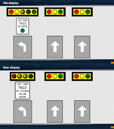
If weather holds, in fact, you'll see our guys out there upgrading the traffic signals along Pat Booker Road through this week and again later in the month. This is all part of an effort to bring the new signals up to snuff with the new standard of protected and permitted movements on urban roads.

What does that mean? Well, put quite simply, the traffic signal industry (meaning the large mass of guys and gals who figure out how to tell drivers when they can and cannot go) has found a better standard of best practices with their turn signals.

While we're at it, we'll also install new Video Infrared Vehicle Detection System sensors (not actual cameras, but sensors detecting the flow and levels of traffic in a given direction) at each intersection and we'll upgrade the street name signs so they're easier to read.

The old signals, which featured a set of five lights on each signal, are being replaced with four-head signal units. The new signals will feature a "left turn yield on flashing yellow arrow" sign. This means if you're fixing to turn left at an intersection and you've got a blinking yellow light, you're welcome to do so - provided the intersection is clear. (That's a key proviso....)

The old system had signs that read "left turn yield on..." followed by a big green dot. The idea was those who wished to turn left could do so with that solid green light, as long as the intersection is clear. The new system focuses more on safety and removes confusion for those thinking they have the right-of-way for their left turn when that solid green light is lit.

The new system is also consistent with the system of flashing yellow arrows installed by the city of San Antonio in 2014.

While we're at each intersection, the signals will be turned off and traffic will be controlled by off-duty police officers. We expect our guys to finish each intersection in about four hours, and should really only be out there in traffic between 9 a.m. and 3 p.m. each day.

If you're super curious, here's the projected schedule (keep in mind weather or other issues may cause this to change):
July 5 - Live Oak Crossing and Village Oak
July 6 – Athenian and Buckingham Village
July 7 – Coronado and Universal City Blvd
July 8 – Rose Garden and Kitty Hawk
July 18 – Northview/Stone Gate, Villa and Randolph Plaza
July 19 – Byrd and National
July 20 – FM 78
July 21 – Aviation*
July 26 – Loop 1604

Note on July 21, while signal crews are at work at the intersection of Aviation, we'll have maintenance crews working to improve the asphalt condition on Pat Booker at the railroad tracks - the goal there is to make your drive a smoother one.

Tuesday, March 22

Want a traffic signal? Here's how it works....

We get, on occasion, a request from folks to install a traffic signal at an intersection location along one of the state-maintained highways across our district. Truth be told, these requests come in with some level of regularity. The reasons for the requests vary slightly, but boil down to a few main reasons:
  1. Congestion levels of roads connecting a residential neighborhood to a main road
  2. Road rage issues with individuals becoming rude or mean in their treatment of other drivers, i.e. cutting people off or not letting others turn onto a road (does this actually happen around here?)
  3. Safety of drivers, kids on buses and pedestrians crossing the road (though these claims are more ostensible than anything)
Truth be told, we conduct routine studies for traffic signals at a number of intersections all over the district. Whether the request has been submitted or not, chances are we've already conducted - recently - a study at your nearest intersection of interest. When these studies are being conducted we're looking for a few things to stand out. Each requirement, or each stand-out item, is called a warrant. The guidelines we follow in these studies are outlined in our Manual for Uniform Traffic Control Devices (MUTCD) section 4C.01. For those who prefer to speak English rather than Engineer, we'll break it down for you.

Warrant 1: Eight-hour vehicular volume
This looks for a certain volume of traffic on the cross street over any eight hours of a given day. Those don't need to be consecutive hours, but can be (for instance) a three-hour period in the morning and a five-hour period in the evening.
There's a minimum threshold we're looking for here, and that minimum threshold is determined by the type of highway and the population density of the area. We look for raw volume as well as potential for interruption of continuous traffic on the cross street. Page 460 of the MUTCD shows a chart and the details of what we're looking for, but generally speaking we're looking for a minimum of 500 vehicles per hour on the main road with at least 120 cars per hour on the side street. That, or we're looking for more than 700 vehicles per hour on the main road with at least 60 cars per hour on the side street.
Though that looks pretty easy to reach, truth is those numbers - sustained over eight hours of the day - can be tough to reach.

Warrant 2: Four-hour vehicular volume
This looks for a certain volume of traffic over any four hours of a given day. This is similar to Warrant 1, but a plot graph is used. On the graph (figure 4C-1 in the MUTCD) you'll have 24 data points plotted - one point for each hour of the day. We're looking for just four points above the appropriate line.
You'll note (if you look at the graph on page 462) three lines here. The bottom line is for intersections where both the major street and side street are one lane each direction. The middle line is for roads with two (or more) lanes on the major street and one lane on the side street (again, in each direction). The top line is for situations where both the major and minor streets have two or more lanes in each direction.
You'll note the volumes we're looking for over this four-hour warrant are significant. If the cross-street holds 80-100 trips per hour, the major street would need to have more than 1,000 trips per hour on a major road with just one lane in each direction. For those keeping score, that's double the volume of traffic on the major road required for an eight-hour warrant.

Warrant 3: Peak-hour vehicular volume
Some intersections are an absolute nightmare (a term we hear often from folks calling in) during a one- or two-hour block during the day, but the rest of the 24-hour period the intersection is nearly a ghost town.

One glaring area that's near and dear to our hearts lately is in the Leon Springs area, particularly between Ralph Fair Road and Boerne Stage Road. That area is absolutely hammered by traffic in the morning for about a two-hour period, and the rest of the day is pretty well free and clear.
At these locations we have the peak-hour warrant, where we're looking for a lot of dominoes to drop all at once. An important thing to remember here is these intersections are given signals only in very unusual circumstances, such as where a major traffic generator is at that intersection (think of the USAA entrances along Fredericksburg Road).
One way to go about this is a plot graph, just as in Warrant 2. The numbers are different again, but this time we're looking for just one or two dots above the appropriate line.
The other thing - and, really, the warrant we're looking at most here, is a combination of three items that must exist. These include:
  1. Total stopped time delay on the minor street equals or exceeds four vehicle-hours
  2. No fewer than 100 vehicles are using the minor street per hour
  3. No fewer than 650 vehicles per hour are turning onto the minor street from the major street
These warrants are pretty darned difficult to reach, and that's kind of intentional. Again, this warrant is one that's to be used sparingly. Why? Because if we started granting signals willy nilly we'd end up with a gridlocked system, bound by a saturation of signals. Our preference is a free-flowing system of responsible drivers with minimal stops along the way.

Warrant 4: Pedestrian volume
This is only used where we've got a high volume of pedestrian traffic and that foot traffic is inhibited by the heavy volumes of cross traffic. This is done by looking at a four-hour period (minimum 100 pedestrians per hour) or a peak period (minimum 75 pedestrians per hour) and follows a similar pattern of thought as Warrant 2 and Warrant 3 using plot maps and curve lines.
If this crossing point is within 300 feet - the distance of a football field - of a signalized crosswalk or an intersection with a stop sign in place, we really won't be looking to install the signal. There are some exceptions to that rule, but those exceptions come with a ton of compelling evidence (including the fact the signal doesn't hinder or restrict progressive movement of traffic).

Warrant 5: School crossing
This is really for areas we have school children crossing a major street and that's the driving reason for the signal. Keep in mind what we're looking for here is a volume of kids crossing the street as pedestrians on their way to or from school. This includes elementary through high school kids.
Before these signals are to be installed, however, we've got to consider other measures. Traffic signals under Warrant 5 are to be, therefore, kind of the last option on the table. We try to address issues like this with warning signs and flashers, school speed zones, use of school crossing guards and so forth - all the normal stuff you'll see in or near a school.
Heck, the MUTCD even tells us to consider installing a pedestrian bridge before installing a traffic signal in a school zone for a crosswalk.
Again, if there's a controlled crossing nearby - within 100 feet - this warrant cannot be met except in very specific circumstances.

Warrant 6: Coordinated signal system
The goal of this warrant is to keep traffic moving in proper platoons to maximize overall traffic flow. This study looks particularly at one-way streets but can also be used on two-way roads. Volume of traffic isn't really the question for Warrant 6, but the spacing between traffic signals. This warrant cannot be used where a signal exists within 1,000 feet, but can be used to construct a signal in a spot where traffic flow can be best regulated.
This isn't a warrant we use very often with the San Antonio District.

Warrant 7: Crash experience
Remember where we said safety was ostensibly cited as a need for traffic signals? This is where we look at the actual data to see if safety is, indeed, an issue. During this portion of the study we look at the frequency of crashes as well as their severity. This is one of those areas where we need an "all of the above" requirement before we can justify a signal. Why? Because a single crash caused by some incredibly selfish and irresponsible individual paying more attention to their phone than to the traffic isn't enough to necessitate a signal. But if there's a pattern ... well, now we have an issue.
First, we've had to have tried alternatives to mitigate the risk of wrecks before immediately going for the signal. This can include stuff like signs and increased law enforcement presence.
We've also got to have more than five reported crashes within a 12-month period that would have been prevented by a signal. These crashes must me more than a simple fender-bender.
Finally, the intersection must meet similar traffic volume requirements found in Warrant 1.
All of this data is compiled and if each of the three boxes are checked, the warrant has been met. To be honest, next to Warrant 1, this one is the big'un. If we see a warrant met here, you can bet the location will be vaulted to the top of our priority list.

Warrant 8: Roadway network
This one is really quite simple: if both roads of an intersection are major roadways - that is, a route that serves as the principle roadway network for through traffic flow, is a rural or suburban highway, appears as a major route on a transportation plan map, connects major hubs or is a surface street with ramps and overpasses - we'll get a signal at that location. That goes for intersections that are projected to become a major intersection.
We're talking about the bigger intersections, too - intersections featuring traffic volumes of about 1,000 cars per hour on both streets. In instances where the intersections are only projected to meet this warrant, we may opt to address the issue with future development projects (say, for instance, we have a plan to expand one of those roadways; we'd include the signal as part of that expansion project).

Warrant 9: Intersection near a grade crossing
This involves proximity to a railroad crossing - that's what engineers mean when they say "grade crossing", is a point where the roadway intersects a railroad.

At issue here is when an intersection is very near - within 140 feet - to a railroad crossing. We see this more than just once along FM 78 through Cibolo and into Marion. We're looking for an intersection where a stop or yield sign would be otherwise used and we have a certain level of traffic volumes. Here we use a plot map similar to what we had in Warrant 2 and Warrant 3, but we're instead comparing traffic volumes on both roadways to the proximity of the railroad crossing. These are found on page 469, for the curious.
The goal with this warrant is to avoid having the traffic stopped at the railroad stack up through the intersection in question, causing potential for unnecessary congestion and safety hazards.

Let's sum this up
One major item of note, verbatim from the MUTCD: "The satisfaction of a traffic signal warrant or warrants shall not in itself require the installation of a traffic control signal."
This is absolutely critical to keep in mind. Why? Because, truthfully, installing a "marginally warranted" signal could pose a safety risk. Per our transportation engineer, "the increase in rear-end collisions on the primary street and the potential for a lot of red-light running on the primary street" make us look long and hard at these intersections before actually putting in a signal. Human behavior is the factor here - drivers just don't like stopping for a small amount of side-street traffic.
These intersections are instead placed on a watch list and, as traffic volumes or other factors change to meet other warrants, they are elevated on the list until they reach a priority level where we'd go ahead and install the signal.
Here's the deal: Traffic signals are expensive. Not just to construct (our price tag is in the neighborhood of $250K, depending on whether or not we already have any conduit infrastructure in place), but also to maintain. Where the signal falls within city limits of one of our major cities, that maintenance (including timing) falls on the shoulders of the municipality. Putting a signal in may mean some strain on the already stretched resources many of these cities are working with.
All that said, safety is our absolute priority. Our top core value is people, and it's incumbent upon us as an agency by the people and for the people of Texas to keep safety measures in place. If there's an absolute need, we'll fill it. If congestion levels are becoming an issue, we'll address that as well.
Most often this is done by adding the signal to an upcoming project - it's actually less expensive this way, as we don't have to mobilize forces for a single intersection, but address the issue with an active construction project. If we have a project programmed in the upcoming few years, we might simply take that route to address the need (if the project budget affords it). If the need is more pressing, we respond accordingly.
Either way, we really are taking a look at our intersections - far more often than many may surmise - and determining actual need against actual numbers available. The more warrants an intersection meets, the higher on the priority list it goes.